


Le Marais et le Château de La Frette

raymondfn
User
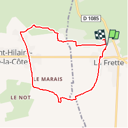

Length
8.1 km

Max alt
458 m

Uphill gradient
114 m
Km-Effort
9.6 km

Min alt
398 m

Downhill gradient
108 m
Boucle
Yes
Creation date :
2019-01-03 19:43:24.504
Updated on :
2019-01-19 10:49:41.125
2h05
Difficulty : Medium

FREE GPS app for hiking
 SityTrail
IGN / Geographical institutes
SityTrail Plus
The world is yours!
About
Trail Walking of 8.1 km to be discovered at Auvergne-Rhône-Alpes, Isère, La Frette. This trail is proposed by raymondfn.
Positioning
Country:
France
Region :
Auvergne-Rhône-Alpes
Department/Province :
Isère
Municipality :
La Frette
Location:
Unknown
Start:(Dec)
Start:(UTM)
684577 ; 5029318 (31T) N.
Comments
